Photogrammetry Data Analysis

TECHNICAL ANALYSIS | DEC 10, 2025

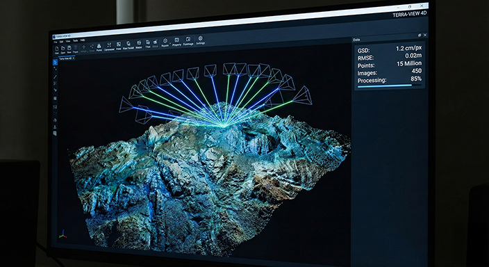
The GSD Factor in Photogrammetric Data Accuracy and Volumetric Error Margins

The precision gap between GPS/Total Station surveys and UAV-based photogrammetry can lead to volumetric deviations of up to 2% in mining operations. How does a Ground Sample Distance (GSD) below 1 cm/px optimize stockpile cost management?

Read Article

References: [1] ASPRS Standards. [2] Journal of Mining Science, "Volumetric Accuracy in UAV Photogrammetry", 2024.

Mixed Reality Geological Modeling

R&D & INNOVATION | DEC 05, 2025

Seeing Underground: 3D Correlation of Borehole Data with Mixed Reality

Geological modeling on 2D cross-sections can lead to engineering blindness in complex fault zones. Visualizing borehole logs directly within the 3D terrain mesh using Meta Quest 3 and MapTo3d reduces uncertainty in reserve estimation by 40%.

Read Article

References: [1] Rock Mechanics and Rock Engineering. [2] International Journal of Digital Earth.

Digital Twin Technology

INDUSTRY 5.0 | NOV 28, 2025

From Digital Twin to Holographic Management: A Paradigm Shift in Site Monitoring

Static reports and 2D maps are becoming obsolete. A 'Live Digital Twin' of a construction site not only shows the current state but also predicts the future through simulations. The era of "Site-on-the-Table" for decision-makers has begun.

Read Article

References: [1] IEEE Access, "Digital Twins in Construction". [2] McKinsey & Company, "The Next Normal in Construction", 2023.